

Petrogyph of the Merrimack River
Abstract
The archaeological site at Mystery Hill, North Salem, New Hampshire (currently known as America’s Stonehenge) contains a number of petroglyphs. This article focuses on one of those petroglyphs. A comparison of the petroglyph to a USGS map of the Merrimack River shows a correlation between the petroglyph and a section of the river in Haverhill, Massachusetts. The authors argue that the petroglyph is a map of the Haverhill, MA section of the Merrimack River.
Location
Petroglyph is on a stone embedded in a wall inside a large intact stone chamber. Chamber has an associated C14 date 1430 +/- 135. Carbon date was obtained from charcoal excavated from a drain that has its entrance inside the chamber. Although drain’s entrance is inside chamber most of its length is outside. Outside drain was boxed-in with stone forming a covered drain. Twenty five and a half centimeters of silt had built up in drain. Charcoal pieces came from undisturbed bottom five centimeters of fine silt. (Whittall, 1977: 18-21)
C14 Dates
Numerous C14 dates have been recovered from the Mystery Hill site NH46-1. Of interest to this article are five dates from the Middle Woodland period of which 1430 B.P. is one. An excavation in 1995 in the visitor’s parking lot uncovered a Native American lodge and yielded the following dates 1910 +/- 190, 1640 +/- 135 and 1195 +/- 75. A 1991 excavation at the North Stone on top of hill near complex of stone chambers recovered charcoal from a fire which dated to 1250 +/-100. These five dates cover the whole range of the Middle Woodland Period.
Lodge indicates repeated visits by Native Americans to base of Mystery Hill. Charcoal recovered from North Stone and from inside drain exiting the chamber with petroglyph indicates Native Americans were active on the hilltop during Middle Woodland period.
Petroglyph (inside chamber)
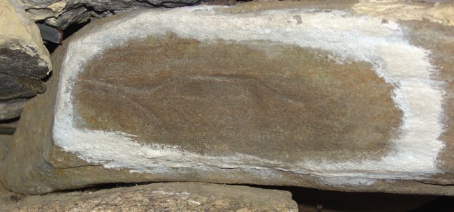
The petroglyph stone is a lintel for a recess in the chamber wall. The petroglyph measures three inches wide by six inches long. The carving has two grooves carved into stone. One groove is a long undulating line starting near middle of stone. It is oriented east to west. On the west end the grooved line curves around in a tight U-shaped bend and then extends out again heading southwest. The second grooved line is above and is oriented east to west. It is a shorter line, curved at its west end where it attaches to top of U-shaped bend. (Fig. 1)
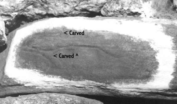
Fig. 1 Petroglyph
Merrimack River in Haverhill, MA
The Merrimack River’s layout in Haverhill, MA has a long undulating stretch that starts in Haverhill and heads west until it reaches Ward Hill in Bradford. At Ward Hill there is a tight U-shaped bend, afterwards the river stretches out again and heads southwest. At tip of U-shaped bend, Creek Brook joins the Merrimack River from the north. Following Creek Brook north from the Merrimack it curves slightly eastward to a split in the brook. Creek Brook continues northward from the split, and an unnamed brook extends eastward from the split to its point of origin in Haverhill. (Fig. 2)
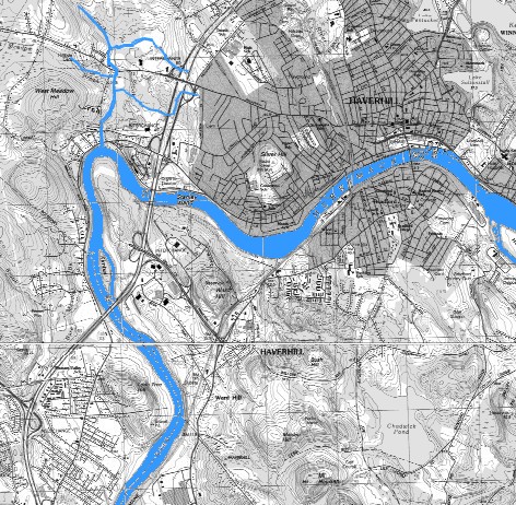
Fig. 2 USGS Map - Merrimack River in Haverhill, MA
Discussion
Figure 3 is a comparison of the Merrimack River (Haverhill, MA section) and the petroglyph. The section of the Merrimack River shown in the figure was traced from USGS Haverhill quadrangle map. The petroglyph was traced from an enlarged photograph of the carving. This comparison shows a strong correlation between the petroglyph and this section of the Merrimack River, Creek Brook, and the unnamed brook.
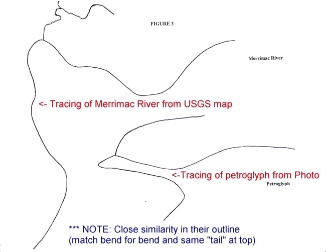
Fig. 3 Tracing USGS map as compared to tracing of photo of petroglyph
(Orginal image was shrunk to fit on webpage)
Conclusion
The petroglyph is an accurate map of a section of the Merrimack River in Haverhill, MA where Creek Brook flows into it. There is a high probability the Native Americans who visited the site came from the Haverhill, MA area.
New Hampshire Site 46-1 Mystery Hill C14 Dates
Radiocarbon Age Laboratory Reported
(Years Before Present) Number Context Reference
1910 +/- 190 GX20669 Lodge 1995*
1640 +/- 135 GX20670 Lodge 1995*
1430 +/- 153 GX4732 Chamber - Drain Whittall 1977
1250 +/- 100 GX15349 North Stone/Fire Hinton 1991
1195 +/- 75 GX20671 Lodge 1995*
*Excavation conducted in 1995 by W. E. J. Hinton Jr, Patricia Hume, and David Stewart-Smith. Results of laboratory report are at posted at America’s Stonehenge Visitors Center. No published reports on the excavation.
Bibliography
Hinton, W. E. J., Jr.
1991 “New Radiocarbon Dates for NH 46-1: Update of Recent Activity at Mystery Hill.” New Hampshire Archaeological Society Newsletter Vol. 6(2): 5-7.
Whittall, James P., II
1977 “Excavation Report: Oracle Chamber Drain, New Hampshire.” Early Sites Bulletin Vol. 5(1) (Feb. 1977) pp. 18-21.
